Steese Highway
The Road That Has it All!
This highway from Fairbanks passes through the Chatanika River valley next to the
trans-Alaska oil pipeline, by gold camps, over rolling hills of tundra, past wildlife, hot
springs and finally to the mighty Yukon River.
Naming of the Steese
The Steese Highway was built in 1927 and named after Gen. James G. Steese, a
former president of the Alaska Road Commission. The first 56 miles of the Steese Highway
are paved, but the rest is two-lane gravel. Although the highway is open year-round,
winter travelers should check on road conditions with the Department of Transportation in
Fairbanks, (907) 451-5204.
Chena Hot Springs Road
Chena Hot Springs Road, which splits off the Steese Highway at Mile 4.9, ends
at Chena Hot Springs Resort nearly 60 miles later.
Pipeline Visitors' Center
Farther up the Steese Hiway, at Mile 8.4, you can get a good look at the
Trans-Alaska oil pipeline.
The pipeline carries
oil from Prudhoe Bay over mountain ranges, permafrost and tundra 800 miles south to
Valdez. Alyeska Pipeline Service Co.
operates a visitors center seven days a week from May to September at the site.
Fox Intersection
One mile farther up the road is Gold Dredge No. 8. The dredge, built in 1928, is open
for tours. A three-way intersection in Fox gives you the choice of turning left into Fox,
a tiny town at the junction of the Steese and Elliot Highways, best known for the Fox
Roadhouse, which has been the Silver Gulch Brewing and Bottling Co. since
February 1998. It is located on land worked over by a gold dredge decades ago, and
Gold Dredge 8 (see above) is one of the local
attractions.
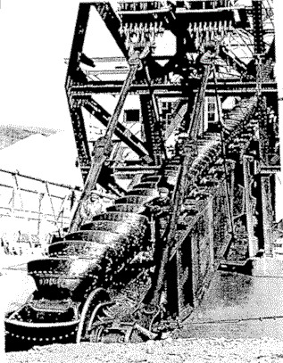
[This photo of the "buckets" on a gold
dredge is from the Lulu Fairbanks Collections in the UAF Archives. If you look carefully,
you will see two men on either side of the buckets, showing the size of the
buckets.]
The two other choices are taking the road north up the Elliott Highway, or
turning right to continue on the Steese Highway. To the right, the highway traverses
several miles of rock and gravel mounds. These are "tailings" from the huge
dredges that mined the area for gold in the earlier part of the last century.
Pedro Monument
At Mile 16.5, a turnout and monument honors the location where Felix Pedro
(Felice Pedroni) is believed to have discovered
gold in 1902, starting the gold rush in the Fairbanks area.
Cleary Summit
The road climbs steeply from here to Cleary Summit. From the small gravel
parking lot at the summit you will have a sweeping view to the north of the Chatanika
Valley. This is a good place to watch the midnight sun
in
late June.
Chatanika Gold Camp
At Mile 27.9 is the Chatanika Gold Camp. This is the site of the old
F.E. Co.
Camp, which was built in 1921 to support 200 Chatanika dredge workers. The camp now has a
restaurant, bar, rustic hotel and three multi-room cabins. "The world's largest
coal-fired cook stove" is used to prepare Sourdough breakfast buffets on Sunday
mornings.
Chatanika was an important gold mining district, and an old gold dredge still
sits in a pond a few miles from Poker Flat.
Chatanika now consists mainly of a few lodges frequented by hungry Poker Flat personnel.
The road follows the Chatanika River for the next several dozen miles. In case
you are "into" fishing, grayling (over 12 inches) on the Chatanika and its
tributaries is catch-and-release using unbaited single-hook artificial lures only, April 1
to May 31. After June 1, the daily bag and possession limit is five. Check with Fish and
Game personnel before you visit, in case there are recent changes to the above guidelines.
The Bureau of Land Management (BLM) has a trailhead at Mile 42.5 which
provides access to the White Mountain National Recreation Area trail system for hikers as
well as ATVs.
Davidson Ditch
At Mile 57, U.S. Creek, you will have one of the best views of the famous
Davidson Ditch, a series of ditches, siphons, and pipes once used to carry water from a
small man-made dam on the Chatanika River to the working gold dredges of Fox and
Chatanika. The Davidson Ditch cuts across the hillside of Poker Flat's middle range; it
was 12 ft wide, 4 ft deep, and ran 83 miles, with another seven miles of 48-inch
pipe. When
it was built in 1925, it was one of the largest engineered projects in the world.
Just past U.S. Creek, at Mile 60, is the Cripple Creek campground,
operated by the BLM.
At Mile 85, the highway comes up out of the Chatanika valley to Twelvemile
Summit (3,624 feet). The south end of the Pinnell Mountain Trail joins the highway at the
ridgetop. The north end of the hiking trail, a strenuous two-day trip, intersects the
highway at Eagle Summit, Mile 107.
Eagle Summit
The summit is the highest point on the road and another favorite spot from
which to watch the midnight sun during the
solstice in late June. On clear days, you will be able to
see the Alaska Range, 100 miles to the south. There is a new BLM-built parking area with a
short nature trail to a deck on the tundra.
It is pretty much downhill after Eagle Summit to the town of Central, where
you enter the Circle Mining District. You are now about 128 miles north of Fairbanks. The
district's historical museum in Central is open from Memorial Day to Labor Day noon until
5 p.m. Featured are antiques from the gold rush, such as an organ from a trading post,
artifacts, an old-timer's cabin and a reading library. A modern-day gold mining exhibit
features 20 types of gold from local placer miners.
An eight-mile spur road takes off from here, leading to the Circle Hot Springs Resort.
Birch Creek
If you like canoeing, you can launch at a BLM facility on Birch Creek, Mile
94. There are some rapids in Birch Creek, and it will take more than one day to float to
the new take-out, at Mile 140. The take-out can also be used as a put-in for a six-hour
float to the Birch Creek Bridge at Mile 147.
Before returning to Fairbanks, you can drive the winding road to Circle, on
the banks of the Yukon River. Before gold was discovered in Dawson City, Circle, founded
in 1893, was the largest gold mining town on the river. More than 1,000 people lived in
the town, which was named in the mistaken belief that it was on the
Arctic Circle, another some 30 miles north. Today, Circle
has a population of about 80. It has a grocery store, two gas stations, motel and trading
post, post office, cafe, campground, boat launch and general store.
Circle is a starting point for travel on the Yukon River. Circle City Charters
offers river transportation and tours all in a covered and heated aluminum inboard jet
boat. Visitors can travel upriver from Circle to the Yukon-Charley Rivers National
Preserve.