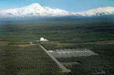
Gilmore Creek Tracking Station
Gilmore Creek Satellite tracking station is located near
Fairbanks, Alaska.
The Gilmore Creek satellite tracking station is operated by the National Oceanic and Atmospheric
Administration (NOAA)
National
Environmental Satellite, Data, and Information Service (NESDIS).
It has provided satellite command and control services for many years, and a long-distance
telephone satellite earth station is located at the site as well.
An ionosonde and riometer are set up on the site and are used by the
HIPAS Observatory.
These
data are not available right now at Poker Flat.
 The HIPAS facility is run by the UCLA
Plasma Physics Laboratory, and is engaged in the study of the ionosphere through the use
of high power transmissions. It is located 25 miles east of Fairbanks. Not everyone thinks
that the HAARP (High-frequency Active Auroral Research Program) is a good thing. In fact, some could even be accused of being a bit paranoid
about it.
The HIPAS facility is run by the UCLA
Plasma Physics Laboratory, and is engaged in the study of the ionosphere through the use
of high power transmissions. It is located 25 miles east of Fairbanks. Not everyone thinks
that the HAARP (High-frequency Active Auroral Research Program) is a good thing. In fact, some could even be accused of being a bit paranoid
about it.
We have been told that the Gilmore station is monitoring weather satellites,
and that they give tours. We are trying to find out more and will update this as soon as
we do.

